Monday 14 March 2011

Sorgenfri to Ølstykke

The sun was shining so it seemed like an ideal opportunity to take a local walk. Having packed my Aarn Featherlite Freedom I set off by bus then train to Sorgenfri, approximately 40 minutes away.

Passing Sorgenfri church I headed down to the Prinsessestien a path between Lyngby and Fredriksdal named after Prinsesse Caroline Amalie this path is also interesting for its approximately 800 year old Oak tree


The path follows and then crosses the canal connecting Farum Sø and Lyngby Sø before reaching Fredriksdal. After which I followed the western side of Furesø. Along the banks of Furesø there was a fascinating mixture of ice, water and debris.


The trail continued along the banks of Furesø and with the sun shining there was excellent views of the semi frozen lake.


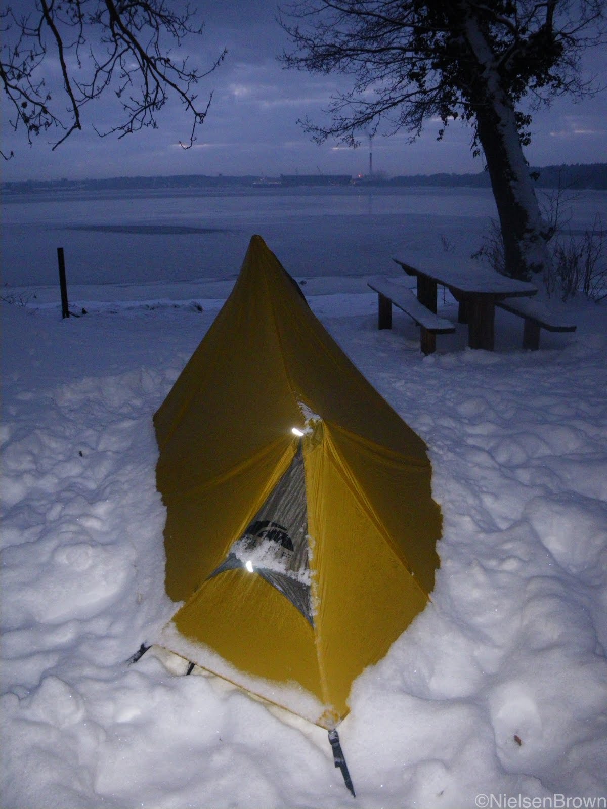
Leaving Furesø I passed under the motorway and headed to Farum Sø, the main trail (Mølleådalen) follows the north side of Farum Sø whereas I chose to follow the south side as the path wended its way around the lake then inland before returning to the lake at a bird watching tower. Soon after which I arrived at an ideal location for the bivy.


The campsite provided excellent views across the lake to Farumgård which was initially established in the 1300's.


After a pleasant night punctuated by the sounds of the Naturugle, I awoke to a misty morning. Setting off along the lake shore then inland and ultimately returning to the Mølleådalen by the banks of Mølle Å which flows Bastrup Sø to Farum Sø. I did wonder if it was possible to pack raft through here but decided there would be more packing than rafting.

Reaching Bastrup Sø it was apparent that the swans were waiting for the ice to melt.


It was in this section that I also passed Bastrup Tårn (tower) a site of an earlier day walk.

After Bastrup Sø the path bordered the forest and the fields as it wended its way towards Buresø.


From Buresø it was through the recently harvested forest to a delightful small ice covered lake Guldbjerg Mose where I sat and enjoyed the hazy sunshine whilst eating lunch. Fishing is allowed here. The final section took me through Sperrestrup Skov before finishing at the railway station in Ølstykke.

It had been a pleasant 24 hour walk and it was evident that spring was coming with the ice melting and many more people out enjoying the outdoors.

Gear Observations.

Nemo GoGo Bivy, this bivy weighs in at just over 1 kg including stuffsack and pump. This was the first trip I have used it on and I was happy with it. There is sufficient room for one with a pack near the door and gear along the sides by the sleeping mat. The airbeam is easy to inflate and provides a rigid structure when assembled. I was able to keep the front open all night so there was no condensation at the front and only a minor amount at rear of the bivy. It is not a light bivy but one I will be happy to use on quick overnight trips again.


Pacific Outdoor Peak Elite AC - Regular Size, recently Phil Turner gave his readers a first look at this new offering from POE, I was impressed and soon as they were in stock at BPL.co.uk I obtained one. I was pleasantly surprised by the weight of the mat which including stuff sack was 345 grams. Now they are perhaps not the ideal height for the bivy but as a side sleeper there was still some space between me and the bivy outer. I was pleased with the comfort of the mat though I did feel some cold seeping through from the frozen ground. At this time of the year I would probably put a thin piece of foam underneath to provide a little ground insulation. I will report on its extended use in due course.

Saturday 5 March 2011

Hareskov to Lyngby

It had been a grey and gloomy week weather wise and with the appearance of sunshine it seemed like a good idea to get out and go for a walk. My only plan was to catch the train to Hareskov station and return from Lyngby station, in between there are three major lakes, Farum Sø, Bagsværd Sø and Lyngby Sø as well as three forests Store Hareskov, Fredriksdal Skov and Nybro Skov. So I set off through Store Hareskov choosing whichever path appealed to me as I walked, I have visited this area on many occasions so I always try to go a slightly different way and with the ice still in the low lying areas and bright sunshine it was easy to find something to look at.


After leaving Store Hareskov I entered Fredriksdal Skov but instead of taking the shortest possible route through the forest I decided to head west which resulted in perhaps the most enjoyable aspect of the walk, because I entered an area that I had not visited before. There are many well trodden (and cycled paths) here but I picked less travelled sections and found myself on the edge of a frozen lake with the ice glistening in the sunshine I located a warm spot out of the wind and settled down for lunch, it was magic.


After a relaxing lunch I sidled around Store Hulsø before climbing away onto another minor trail trail which ultimately provided me with beautiful views of the windswept and partly frozen Farum Sø.


At this point I was glad of my macpac fleece, Icebreaker shirt and especially my Montane Litespeed which ensured the wind did not penetrate. I followed the shoreline of Farum Sø before crossing over into Nybro Skov which took me to the banks of the canal connecting Farum Sø and Lyngby Sø


By now there were many people wandering the trails around Lyngby Sø, but I was still able to find my own sense of enjoyment in what is an area not more than 10 km from the centre of Copenhagen.

Monday 14 February 2011

Blowin away

Alighting from the train I headed into Tornby Klitplantage and set up camp for the night it had been a cold clear and calm sunny day, sadly for me most of the day had been spent on the train.


The following morning I awoke to an ice encrusted shelter, having had breakfast I set off on the frozen ground towards the coast as the clouds gradually built with a breeze strengthening. I crossed Liver Å on the bridge and it was evident that any moisture in the sand had frozen whilst evidence of sand slips above the bridge ensured that every step was taken with care.


The trail took me through many summer house areas as it skirted the coast line and with the wind increasing the sun covered in cloud there was little time to hang around, it was cold. Finally descending and then walking along the beach to Lonstrup before heading through this quiet windswept village and once again turning south west towards the highlights of the days walk.


The coastline here is subjected to the force of the wind and the North Sea and as a result the coast line is forever changing and with many buildings gradually getting closer to the cliffs and ultimately disappearing. Such is the case with Mårup church originally built in the 1200's about a kilometre from the sea, it is now less than 10 metres from the sea.


To the south of the church lies Rubjerg Knude and accompanying light house, as I climbed to the top of the dune the windswept sand ensured that my face was kept buried in my Tuara.


Fortunately much of the sand was frozen and as such it was not too bad, I can however imagine the sand storms that must rage through this area at times.


The sand around the lighthouse was hollowed out making a veritable wind tunnel and it was interesting to see that the lighthouse originally built in 1899 was surrounded by outbuildings but now only the tower remained. The lighthouse was decommissioned in 1968 and the fight against the sand drifts was given up in 2002, once again demonstrating the power of nature.


Leaving the sand dune the trail descended into the peaceful sheltered tranquility of a small forest, it was here, sheltered from the wind, I had lunch.

The afternoon took me through Nørre Lyngby another town threatened by the encroaching sea.

Leaving Nørre Lyngby the trail followed the sea and I slipped and slid over many large ice patches on the sand (should have packed my micro spikes) while there was more evidence of the power of the sea over man made structures.


The cliffs provided some respite from the wind, however, it was evident that the wind was increasing and the accompanying windchill ensured the temps were dropping into the the negatives teens I decided that it was time to find a sheltered spot for the night and a small cabin seemed ideal. Having booked into the cabin, on the outskirts of Løkken, with forecasts of wind speeds ranging between 15 and 20 metres per second for the coming days and with temps below zero combined with a possible reoccurrence of an old injury I felt it was time to head home.

Some gear observations, the Haglöfs Ozo Pullover was perfect for such conditions and it has possibly the best hood of any jacket I have used.

The MLD Speed mid is an ideal size for one and provides enough space should the weather turn bad, this will be going on more trips.

For the trip I used the Snowpeak Gigapower Ti Stove and I used 20 gms of gas per litre of water.


I will be back, as there are many more beaches to walk.


Tuesday 4 January 2011

Gear Observations: Gendarmstien

For this trip I was expecting snow and temperatures in the range of -15 to -5 degrees C with possibly some snow falls and mild winds, which turned out to be correct. Some of my gear reflections follow.

Sealskinz gloves


The biggest surprise for me was the Sealskinz gloves, the air was cold and along the coast windy but there was no rain, however, I often had my hands in the snow. These gloves whenever worn kept my hands dry and warm even when used to remove snow from the signs, benches etc. occasionally I combined them with Goretex overmitts which further helped to deflect wind and keep my hands comfortably warm, not uncomfortably numb. Though the outers did get damp during the day they felt drier the next morning having formed part of my Paramo Vista pillow. For those considering these gloves in my view they are worth a look, with the caveat that I did not use them in rainy weather.


Feet

For this trip I wore my old pair of Innov8 390 gtx boots and I was very happy with the grip they provided on most surfaces, they were partnered with Bridgedale liner socks and Seakskinz socks, for the most part my feet were kept dry and warm. The Sealskinz helped to form a waterproof layer as well as providing some insulation from the cold. Some water did seep through the socks but at no time were the liner socks more than damp (possibly from sweat). Under similar conditions I will use this arrangement in the future as well as trying the sock combinations with my Terrocs for summer, an arrangement used by Colin Ibbotson as well as described by Jörgen Johansson in Smarter Backpacking

Shangri La 1


I have always been interested in this shelter, especially as it reminds me of my first shelter many years ago, though I was always concerned with entry and exit with the pole located in the centre at the front, however, I found this to be less of a problem than expected especially when the front pole is angled away from the inner slightly. The shelter is easy to set up and is spacious inside especially if you pull the centre side tie outs out a little which does reduce the head height in the middle of the shelter as shown in the following picture. The inner net is a little more problematic, it seems the best option is to attach it before erecting the shelter, I prefer not to do this. I am also surprised given the attachments for the floor why attachments have not been fitted to the inner net to allow fixing to the shelter. Having said all this I found the combination of the outer and inner to work well in the conditions which were well below zero and without any wind it was evident that inside the innernet and shelter felt warmer than being outside when the temps were below - 10 C. Overall I was very happy with the shelter and felt that for the conditions it was used it it was an ideal shelter and seems ideally suited to long distance treks where a small footprint may be required.


Primus Express Spider, I used this stove to boil approximately 600 mls of water 2 times a day. Often the water had some ice floating in it and whilst not recording the time taken to bring the water to a boil it did not seem excessively long. The average fuel consumption for the trip was 24 gms of gas per litre boiled using Primus power gas which is a mixture of 25% Propane: 25% IsoButane: 50% Butane which as shown by BPL (Membership of BPL required) is more efficient at lower temperatures when compared with the standard 30% Propane: 70% Butane mixture.

Moisture in sleeping bags, I used a Nunatak Arc Alpinist (with Epic outer) for the trip and each night there was some condensation in the foot, partly caused by my desire to dry my damp liner socks. Over the course of the 3 nights the sleeping bag gained 40 gms in weight (or approximately 5% of its weight). There was also some loss of loft but I remained comfortably warm at all times without the need for my Western Mountaineering Hooded Flash Jacket.

Aarn Featherlite Freedom, this was my first trip with this pack and I was happy with it and felt that the harness more suited me than perhaps the Mountain Magic did. There was ample space in the pack with the Sports balance pockets (10 litres in total) on the front. The interesting feature of the pack is the internal divider in the waterproofliner, it can provide some challenges packing until you become used to it, but otherwise it is an easy pack to load with an excellent roll top closure. I will write more on this pack once I have used it a little while longer.

Saturday 1 January 2011

Gendarmstien: Padborg to Skelde Kobbelskov

The weather forecast for the week was for a little snow and clear cold conditions with temperatures ranging between -15 and -5 degrees C, it was to be a cold trip.

The Gendarmstien is a 74 km route from Padborg to Høruphav and follows the border between Germany and Denmark mostly along the coastline of Flensburg Fjord. The Gendarmstien was patrolled by Danish police between 1920 and 1958 and the path now forms part of the European Long Distance Route 6 (E6).

I set off from Padborg Station as large snowflakes began to fall, no doubt getting a few strange looks from the locals wondering why would anyone go backpacking at this time of the year. I soon realised that whilst many people had been out walking and the snow was only supposed to be 15 cm deep, it was very powdery and soft. It was grey and cold as I started along the Gendarmstien.


Once settled into my normal walking pattern I soon noticed the first of many Grænsesten each individually numbered and with a sighting line to the next Grænsesten in each direction.


However, there was also this strange object which looked like some form of listening post, I wondered if the Gendarme stood there listening to their favourite music? Anyone who has a suggestion on what this is I would be very appreciative of further information.


Soon after passing the "listening post" I came to one of the border gates now open for easy access, however, I can imagine in days gone by it was a lot more difficult to cross the border here.


Soon after passing the border gate I found myself on a section of the trail which was much less travelled and drifts of up to a metre were common as was "post holing" making for slow and tiring going. Snowshoes would have been useful but they did not arrive in time, sadly.

Fortunately though there was not too many drifts and I finally reached Kollund Skov my intended home for the night. The campsite provided a view across the fjord to the large city of Flensburg resplendent with its cathedral and ship building yards.


I required no encouraging to go to bed, it was cold out and I went to sleep to the sounds of sirens in Flensburg. In the morning I was awoken by the church bells, or was it the horns at the shipyards, not sure. It was still early as took a look around in the grey pre dawn, it was a calm morning.


After packing up, having had breakfast in bed, the luxury of it all, I was on my way and the sun began to make its presence known albeit weakly as I wandered through the beautifully wintery Kollund Skov.


The trail took me through the small township of Kollund Strand before heading inland to the snow encrusted Kollund Dyrehave.


As I headed east towards Rønshoved, I passed this beautiful ice and snow covered lake, magic.


Finally returning the fjord coastline a constant feature for much of the remainder of the walk.


The walk along the coast brought with it frozen ice and snow covered sand, which in most cases was okay for walking upon, but every so often a patch of ice hidden by snow would remind me to take care.


As I headed towards Dalsgård, I found some of the deepest drifts of the trip and with a fence on one side and tree covered cliffs on the other I was left with no option but to wade, crawl, though metre deep snow, fortunately this section was only about 100 metres in length. However, after passing through Stranderød I was informed by one of the locals that it was just as bad further along. I decided to try my luck on the beach but with the small ice covered rocks it was almost as bad, but different. Finally though I climbed away from the beach before descending again past the Dalsgård Fyr.


Climbing away from the beach the Dalsgård homestead glistened in the afternoon light and made for a very memorable sight.


After passing the homestead I followed the coastline before heading inland away from the Gendarmstien to the nights campsite Syvstjernen in Gråsten Skovene, as I entered the forest I noticed the owl inspecting my gear closely.


Syvstjernen, is a popular area and requires booking for groups at certain times of the year. Much to my surprise, 8 Danes arrived to stay the night, this was their third visit at this time of the year and I was the first person they had seen in those 3 years staying out here. They had carried their large packs about 500m from the car park and were fully provisioned for the night including Salmon for dinner. The -15C temperatures and the struggles for a decent fire ensured that we all retired early.

It was a bright, sunny cold morning as I headed off back to the trail via Gråsten before crossing the Egernsund Bridge.


On this cold clear day I passed by many old and new houses with views across the ice covered fjord to Germany. The marina was almost empty now but I could easily imagine the bustle of boats, people and vehicles during summer.


As I followed the coastline towards Brunsnæs there was plenty of evidence of wonderful ice sculptures brought about by the cold. There were many examples of what I dubbed "Ice Swans"


Fishing nets and boat moorings also provided ideal places for ice sculptures to grow.


Finally passing through Brunsnæs I left the coast and headed inland before turning east along a road, I was thankful that they had cleared this road as I could see myself still wading through snow until the thaw.


By now it was getting late and as I climbed towards Gammelgab the sun was beginning to set providing wonderful colourings on the ice.


As it was getting dark and with still a few kilometres to go it was a hasty walk with little time to take in the surrounds, but given tomorrow was the last day I had time to back track and visit some of the beaches again. I arrived at Skelde Kobbelskov to discover that most of the campsite was also a wind tunnel, fortunately I was able to find a small place out of the wind which still offered views of Sønderborg across Sønderborg Bugt.

It was a leisurely start the next morning and I was able to take the time to look at the ice covered trees suspended in the water, though the wind ensured that standing around for any length of time was not an option, so I headed off along the coast towards Kragesand.


With the wind came the cloud but the coast providing many fascinating scenes such as ice covered rocks.


Snow covered cliffs, I even wondered if there was a need for "avalanche warnings" as there was evidence that large lumps of snow had collapsed onto the beaches below.


Finally returning through Skelde Kobbelskov I came across the composition of fungi, timber and snow.


It was a cold, and at times challenging walk but one that was very enjoyable and therefore a walk I can see myself revisiting in winter or summer.

The waypoint map can be found here